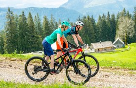
Details for: Panorama route SHORT
Brief description
Magnificent views into the Ybbs valley - the name says it all. Forest trail: 4km, asphalt: 7km
Description
Hollenstein - Ziegelauersattel - Königsberg - Thomasberg - Hollenstein
Starting point of the tour
Hollenstein, Raika parking
Route description Panorama route SHORT
The starting point is the Raika parking lot (460m). Follow the signposting through the town center and turn left at the Renner hairdresser, heading towards the school. On Königsberg street to the intersection at the water reservoir (1.2km/520m) and then leisurely to the Guger junction (2.3km/520m). From here uphill past the Rain farmhouse (3.5km/685m) through Beerenhalde to the trout pond (4.4km/685m) and then turn left to the valley station of the Königsberg ski area. Passing the guesthouse and MTB inn Jagersberger, continue on the forest road through the Bachlerwald to a rest area in the herb garden with a Kneipp basin (6.2km/770m). This is also the highest point of the panorama route.
Now descend along the field path and forest road past the Thomasberg farmhouse (7.4km/680m). Here, turn sharply LEFT and continue downhill past the elementary and secondary schools back to the starting point in the town center of Hollenstein.
Directions
Coming from Vienna, take the A1 to the Amstetten West exit, then B121 to Waidhofen an der Ybbs, from there continue on B31 to Hollenstein an der Ybbs.
Coming from the west, take the A1 to the Oed exit, via Aschbach Markt on B121, continue on B121 to Waidhofen an der Ybbs, from there continue on B31 to Hollenstein an der Ybbs.
Parking
Parking lot at Raika
Author's tip
Take a look at the "Sheep Cheese Express" at the end of the route.


